Typically customers have set up their SWAF application to use a particular application coordinate system and then they forget about it.
With the VE Connector, rendering can happen in any coordinate system but as you can probably appreciate, the fastest and highest quality rendering can happen if the current map view's coordinate system is the same as the coordinate system that Microsoft's Bing Maps (formerly Virtual Earth) were cached at. So the VE Connector comes with a pre-defined coordinate system (we call it "Virtual Earth") that switches the mapview coordinate system to the same one used by Bing Maps.
Changing the mapview coordinate system has typically caused our customers two "surprises".
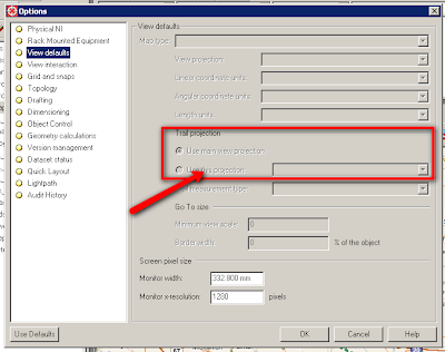
The first surprise is that their trail measurements are now different than they used to be. The second surprise is that their application coordinate system is different that it used to be.
The first surprise is that their trail measurements are now different than they used to be. The second surprise is that their application coordinate system is different that it used to be.
Both these "surprises" indicate that the trail coordinate system and the application coordinate system have been "locked" to the mapview coordinate system.
You can change these settings by choosing Tools -> Options from the menu bar.
To change the application coordinate system so that it is always what you want it to be regardless of the current mapview coordinate system, select Geometry Calculations in the Options panel.
To change the trail coordinate system so that it is always what you want it to be regardless of the current mapview coordinate system, select View Defaults in the Options panel and "unlock" the trail coordinate system from the mapivew coordinate system.


No comments:
Post a Comment